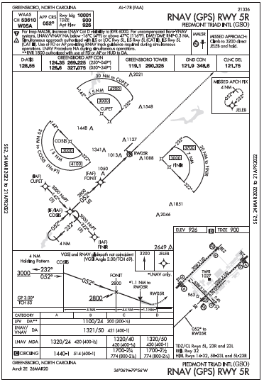
TAA segments for instrument approaches have defined descent profiles tied to distances from specific fixes, and once cleared for the approach without altitude instructions, descent to these altitudes is optional.
Monitoring ground speed is critical during approach and landing, especially when encountering wind shear or hazardous runway conditions (like ice/frost), which can severely impact aircraft control and stopping ability.
Some instrument approach designs can be counter-intuitive; for instance, an approach designated for one runway might technically lead straight to a more suitable, better-equipped runway, yet still require higher (circling) minimums for landing on the latter due to its official designation.
When looking at the KGSO GPS Rwy 5R approach in “Gettin Down” from June 2022, I thought the TAA in this case was the 30 NM arc from COSIS. So at 25 NM heading 052 toward COSIS I should be at 4100, at 13 NM 3000. Once cleared for the approach without altitude instructions I should change altitude. Is the TAA just the “T” at COSIS?
CREATE A FREE ACCOUNT
Sign up to keep reading
Create a free account to continue. Already a member? Sign in below.