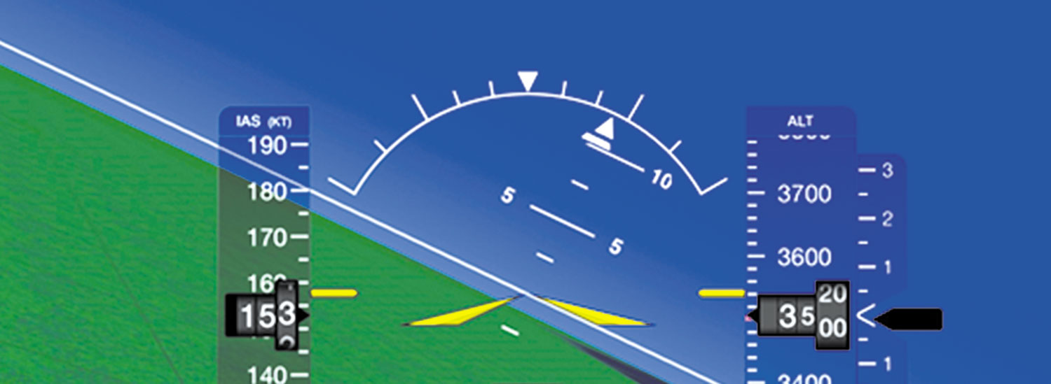
Only Partially Correct
Question 11 in the April (2024) quiz asked about the duration of a TAF. The correct answer said 24 hours, but that’s only half right.
International airports can have a TAF with a 30-hour duration to allow dispatching longer inbound international flights.
—Sal Cruz, Watsonville, California
You’re absolutely correct, Sal. Thanks for pointing that out.
Bloody Sky Pointer
Your June 2024 article on display options got me stirred up all over again. I got my last type rating a year ago after flying mostly light GA and remaining instrument current for many years. I had a miserable time with the bloody sky pointer the first day in the sim. Why are there even options on the AI?
We standardized the six pack for safety in 1968. There is absolutely no excuse for not standardizing the pointer. People have died. For goodness sakes that includes the Buddy Holly crash half a century ago.
—Rick Durden, Bonners Ferry, Idaho
Just received my June 2024 magazine. In your “Options: Good/Bad News” article Luca Bencini-Tibo talks about different roll pointers. This is not a trivial issue. I have been flying large aircraft with sky pointers for decades and I really love that display. I think sky pointers are the way to go.
I also own a small single-engine airplane. About two years ago I decided to replace my vacuum instruments with an electronic flight display. The PFD I chose was the Aspen E5, in part because it looks almost identical to the larger Honeywell PFD in my work airplane. I figured it would be a seamless transition, but in reality it wasn’t.
In the ultimate case of expectation bias, I was shocked—though I probably shouldn’t have been—after the installation of my new E5 that it does not use a sky pointer, but rather a ground (fixed) pointer like most GA instruments. I mean, it literally looks like a miniature of the Honeywell display I fly with at work until you bank the airplane and find that the two triangles that meet at their vertices when the wings are level are reversed from the Honeywell display.
In the beginning I was okay with the E5 in a moderate bank because the horizon was obviously banked in one direction or the other. However, making small corrections within 5 degrees of wings level was really annoying because my brain wanted the E5 to work the way the Honeywell PFD works. I am finally at the point now where I can mentally separate the two PFD’s, though I am really much more comfortable with the sky pointer.
To add context, the original vacuum-powered horizon in my personal plane was not a sky pointer either, but the symbology was dissimilar enough from my work plane that I never had any misinterpretation issues.
Now that I’ve had the experience myself, I’m really amazed that the FAA can, at the same time, certify two opposite protocols for interpreting aircraft attitude. An Aspen tech rep told me there is no provision for swapping protocols in their PFD’s. If there had been, I would have done it immediately. There have to be other pilots out there faced with this issue. Plenty of professional pilots own personal airplanes.
—Bill Kelly, Palmdale, California
We’ve gotten similar feedback from others. Although a less common debate, we’ve found the sky-vs-ground pointer discussion has folks as passionate as north-up versus track-up map orientation. Some don’t seem to care and can work with either easily, while others really struggle with one or the other.
Yet More #$%& Codes
“Flight Plan Codes” in your May 2024 issue was interesting right up to the point where Block 18 PBN was limited to GPS only, as if the large number of aircraft flying without GPS don’t exist. I’m fine if that is all that they want to talk about; but at least give a reference to where to find the information as it is kind of important for all of the rest of us who do fly. Or are we PNB/NA?
—Lyle Noordhoek, Hays, Kansas
Fair question, Lyle. But standard VHF nav (VOR/LOC/ILS) is not viewed as offering PBN. And since VHF nav is all you would put in block 10, there’s no need for any PBN clarification in block 18.
I should know better. As soon as I wrote and we published, “Flight Plan Codes” in May 2024, the latest AIM update announced obscure changes that I didn’t cover. As it turns out, those changes were published before they’re usable.
In Block 18, the article mentioned that SUR/260B or SUR/282B refer to the RTCA (Radio Technical Commission for Aeronautics) standards for ADS-B Out through an extended-squitter transponder (SUR/260B) or UAT transceiver (SUR/282B). However, in AIM CHG 2, effective March 21, 2024, the block 18 SUR/ codes now must show the type of “emitter” rather than RTCA standards.
The new codes will reflect the type of “flying object,” such as an airplane with less than 15,500 pounds max takeoff weight, glider, parachutist (with a transponder?), or unmanned aerial vehicle, to state only a few. The complete list of emitter codes can be found: https://www.adsbexchange.com/emitter-category-ads-b-do-260b-2-2-3-2-5-2/. However, the most recent AIM Appendix 4 now has this table with only one type of emitter.

A2 refers to airplanes between 15,500 and 75,000 pounds max take-off weight. For typical GA weights under 15,500 pounds, although not shown in the table, we should be using A1.
But not so fast. From a very reliable FAA source: “However, it’s important to note that FAA JO 7110.10 isn’t yet compatible with these new codes. As a result, flight plans will not be accepted if filed with these new codes. This is a current limitation. Right now, Leidos FSS is contracted to, and is following the 7110.10AA. The latest rumors are that they will soon upgrade to 7110.10CC, where currently, version 7110.10DD with change 1 is the newest. The short answer is that it will be some years before this becomes something you can actually file through ForeFlight, Garmin Pilot, and other vendors, as most use Leidos FSS.”
So, the AIM incorrectly tells us what to use, but we can’t use it yet.
—Luca Bencini Tibo, Westin, Florida
Maximum Holding Altitude?
The March 2024 article, “Improving the NAS” talks about a maximum altitude for the HILPT at JADGU in the RNAV (GPS) Rwy 20 approach at Alamosa, Colorado. Why would there ever be a need for a maximum altitude since you could always descend in the hold to the minimum before beginning the approach?
—Robert Gorecke, Las Vegas, Nevada
There are a couple reasons a maximum altitude might be established for a hold. The simplest is that there might be airspace or a procedure above so holding traffic is restricted lower. But the situation at Alamosa is more confusing.
As an aircraft’s altitude increases, typically so does its speed. As speed increases, so does turning radius. So, the surveyed protected airspace for a hold increases with altitude. But this hold was not protected at those higher altitudes (speeds). With the even higher terrain to the north and east, aircraft from those directions were entering the hold at altitudes that were too high for the obstacle evaluation as they descended in the hold for the approach. There was risk that some aircraft at those higher altitudes and speeds were not being properly protected from the terrain surrounding the hold.
GPS Shouldn’t Be Only Nav
Years ago, flying into Aviano Air Base in Italy after making a successful Atlantic crossing we experienced a navigation error. Nearing Aviano at 4 a.m. local time I noticed that the DR light was displayed on the GPS navigation equipment. I spoke to the captain and asked how long that had light been on. Neither of us knew, however the autopilot was still engaged and the aircraft was flying along wings level with no navigation guidance selected. We had one INS (inertial navigation) unit and two GPS units along with the standard VOR and DME, so we were technically not “lost.”
Wondering how this happened I asked the people in the tower, and they replied that the GPS signal was intentionally disabled so civilian and enemy forces did not have access to the signal, but the U.S. military were not restricted. While this is rare, this is a point worth considering when relying solely on the autopilot coupled to GPS.
—Mike Berry, Phoenix, Arizona
We read ’em all and try to answer most e-mail, but it can take a month or more. Please be sure to include your full name and location. Contact us at Frank@IFR-Magazine.com.


