fbpx

Learning to Fly in Smoke and Haze

Smoke from Canadian wildfires can affect flight training. Here's what you should know.

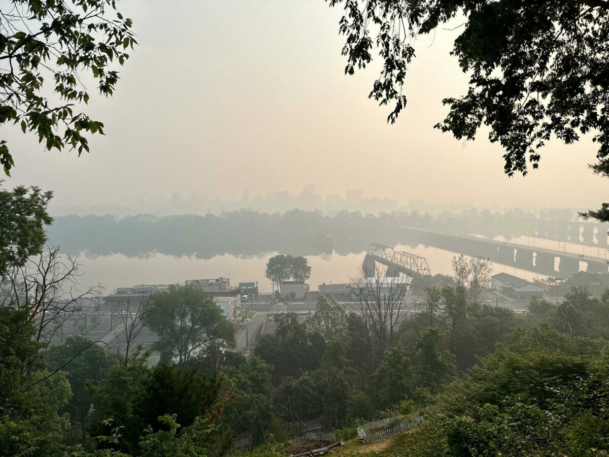
Ask a private pilot applicant what kind of weather phenomenon generates low visibility and instrument flight rules (IFR) conditions, chances are you’ll hear “low clouds and fog” before you hear “smoke.” It is the latter, however, that’s putting a damper on many training and recreational flights on the east coast and parts of the midwest this week. In this case, the smoke is coming from wildfires in Canada and drifting southward.

According to the New York Times and NBC, residents of the smoke-impacted areas are being warned that the conditions are hazardous for all age groups, and advised to stay indoors and wear masks outdoors. A check of the TAFs and METARs in all states bordering Canada showed a fair amount of FU (smoke) and HZ (haze) in the reports. More disquieting were the predictions of thunderstorm activity in several states—bringing  the threat of more wildfires.

In Washington state, we’re awaiting our turn for both fires and smoke events. In the Seattle area the winds predominantly blow north and south—a look at the Seattle TAC or VFR sectional shows that the runway alignments confirm this. Most of the airports in the greater Seattle area with paved runways have spans aligned north-south. The exception is Olympia Regional Airport (KOLM), which still has an east-west runway as it was a training base during World War II, and these airports were designed with at least one definitive crosswind runway.

If there are fires in Canada and the winds from the north, we will get the smoke. If there are fires in California or Oregon and the winds are from the south, we will get the smoke. And, just to be festive, if there are fires in Montana, Idaho, or eastern eastern Washington and we get some of those rare gnarly winds from the east, we are going to have a smoke event. And it may stay in the Seattle area for a bit, held in place by the Cascade Mountains between Seattle and eastern Washington and the Olympic Mountains on the west coast of the Evergreen State.

If the air quality index is “unhealthy,” most people don’t want to venture outside unless they have to, so that means no flight training. Indeed there are flight schools that temporarily ground the fleet during these events to protect their employees and customers—and probably the aircraft too, as the smoke can’t be good for the engines.

Haze is a different story. Less physically damaging than smoke, it can be a useful teaching tool, provided you take some precautions. For starters, be prepared to file an IFR flight plan and get an IFR clearance  or at least flight following before takeoff. This is a precautionary measure, just in case the haze turns into smoke, and/or the TAF and METAR are optimistic about the reported ceiling and visibility. I do this when I fly with my non-IFR rated clients—it gives us another layer of safety as—in addition to the iPad with the ADS-B—the controllers are keeping an eye on us and warning us about other aircraft in the vicinity. In haze it can be difficult to see other aircraft and even more difficult to determine distance between, as haze makes your eyes focus to infinity.

There have been many pilots who have taken off in VFR conditions, then encountered significantly reduced visibility at pattern altitude or slightly above, then climbed through a layer to break out on top in clear blue sky. That layer of haze and smoke is solid, like a bathtub ring, and in some areas, can be so thick it makes it very difficult to see landmarks on the ground.

Before we leave the pattern, I ask the learners to open their sectionals and TACs and find pronounced landmarks located 3, 5, and 6 nautical miles from the airport. Then when we launch, I ask them to find these landmarks from the air. Can you see it? Kinda? That’s what haze does. You may have to remind yourself that the water tower, freeway overpass, etc., are only three miles from the airport (because you measured with the plotter on the sectional on the advice of your CFI), but it sure looks farther away due to the haze.

In 2020 the west coast had a week of Martian-red and sepia-tone skies brought on by wildfires. It was eerie because although the fires were hundreds of miles away, you could smell them. I was tasked with helping a learner move an aircraft for an upcoming inspection. As we were preflighting the airplane, we both were surprised to find ash falling from the sky and the end of the runway disappeared into haze. We made the decision to terminate the flight just as our respective cell phones went off with warnings from the local health department about the air quality index reaching “UNHEALTHY” (you know it is bad when the health department sends out the automatic texts in all caps). Local stores ran out of air filters for homes and cars and several flight schools grounded their fleets, fearing engine and cosmetic damage to the aircraft. Aircraft owners with ramp parking sports made sure their cowl plugs were installed and air vents were closed or blocked. Those who didn’t have cowl plugs or vent plugs creatively applied rags, painter’s tape, and sponges to protect their aircraft.

That smoke deposited a fine patina of particulate on everything left outside. At the end of the day it was thick enough you could write a message. When the smoke lifted extra care was taken to wash the aircraft because of the concern the particulate could scratch the paint and plexiglass windscreens and windows.

Be prepared

Smoke can roll in quickly. One summer day I was returning from a cross-country flight with a pre-solo private pilot learner when we saw a layer of something coming in from the southwest.

“Is that fog?” the learner asked.

“It’s smoke,” I said. “Can you smell it?”

He said he could, then remarked that it must be a very large fire to be generating that much smoke so quickly. We had been flying for just under two hours, and there was no fire when we took off.

We were approaching from the southwest. The smoke, looking like something out of a sci-fi show, was creeping toward the airport. Parts of the Gray Army AirField and McChord Field Airport (the airports that make up Joint base Lewis-McChord) were hidden under a blanket of beige.

The learner pulled up the AWOS of our destination KPLU. It was reporting variable winds and visibility of six miles and a ceiling of 4,000. We were both skeptical, based on what we were seeing out the windscreen. 

There was a brief discussion of diverting, then I suggested we ask for the RNAV 35, the one and only IFR approach into the airport. We could still see the airport, and the approach was a precautionary measure. The learner agreed.

I handed the learner the plastic IFR hood from the backseat, telling him we were going to make it count—he had thus far flown at 1.3 hours under the hood as part of his private pilot training.

While he put the hood on I called approach and requested the RNAV 35 to KPLU. The controller advised us they had been getting reports of smoke, and asked for a PIREP. I gave a PIREP and repeated the request for the approach. A moment later we were granted a clearance for the RNAV 35 into KPLU commencing at ALDER. We were advised to proceed direct ALDER. This put us south of the airport. I acknowledged the clearance and showed the learner how to program the GPS and how to interpret what it showed us.

The learner was anxious. Although he had flown under the hood before, he had never actually flown an instrument approach. I advised him to focus on maintaining the assigned headings and altitudes and when the time came, the descent—just like we had practiced. I offered to fly the radio to lighten his workload. He agreed, demonstrating his mastery of crew resource management.

The learner glanced out the window and muttered this was not the weather the AWOS was saying it was, because unless we looked straight down we had a hard time seeing the ground.

We were handed off to another controller. Here’s where it got amusing: the smoke must have turned me into Peppermint Patty, because the controller kept calling me “sir.” It added some much-appreciated levity to the situation and helped the learner relax.

I verbally briefed the approach, applying the IFR acronym MARTHA. The 5Ts and the appropriate checklists were also verbalized at the proper time.

He made me proud when he acknowledged, “Checklist complete.”

I am happy to report he did an awesome job flying the approach. He held altitudes and headings, nailed the descent rate of 500 feet per minute and stayed ahead of the airplane like a seasoned instrument rated pilot.

The controller dropped us just outside the final approach fix, but we could see the runway. Or rather, I could. The learner stayed on the gauges until he was told to look up to verify the runway environment, the paint, pavement, and lights, etc. He made the final radio call on the CTAF and the landing was uneventful.

Office Mom was waiting for us—she was concerned we’d have to divert to another airport because of the smoke.

“Nope,” said the learner, glancing at me. “Learning has taken place.”

In the debrief, we talked about ways to address the situation.

Maintain Situational Awareness

Is that fog or smoke out there? Neither one is good when you are a non-instrument rated or lack instrument proficiency. He suggested that he could check the automated weather at the airports along his route, and if he saw something moving in, he could divert.

Determine Your Options

The learned replied he would have headed north to one of the airports he had been signed off for because they were not under smoke. He knew he had the fuel for it, because we had taken off with full fuel (40 gallons) and he determined, based on his performance calculations, that we would burn no more than 14 gallons during the instructional flight. He proved it by sticking the tanks and showing the fuel level on the pipette—he was darn close.

Login

New to Flying?

Register

Already have an account?