

Today, pilots who fly the latest model aircraft benefit from glass panel equipment with the latest GPS technology. However, many pilots in older aircraft have to rely on other means of navigation or want to have a backup unit if their electrical system quits. A portable GPS unit could offer you peace of mind if you find the right one. There are plenty of options on the market.
Quicklook: Best Aviation GPS
- Garmin Aera 510: Best choice for your budget
- Garmin Aera 660: Best choice to replace a tablet
- XGPS190 GPS + ADS-B Dual Band Receiver with AHRS: Best choice for versatility
- ILEVIL Sport portable AHRS GPS: Best amount of simultaneous connectivity
- Garmin Aera 796: Best premium option
- IFLY 740B: Best 7-inch display for the money
6 Best Aviation GPS Options
Whether you’re looking for the best handheld aviation GPS, or something a little bigger and with more features, there are several excellent models to consider that are suitable for all budgets.
Garmin Aera 510
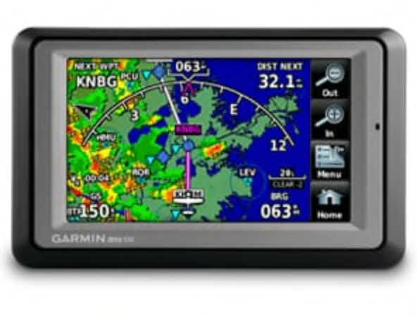
Best For:
The Garmin Aera 510 is a step up from Aera 500, adding support for NEXRAD imaging and SiriusXM Satellite Weather. Aera 510 combines the best moving-map display features with intuitive, menu-driven touchscreen control. It has a 4.3-inch QVGA wide-format touchscreen and is preloaded with detailed aerial mapping of terrain contours and structural components to help decision-making.
Dimensions: 5.3″W x 3.3″H x .9″D (13.5 x 8.4 x 2.3 cm)
Weight: 9.5 ounces (270 g)
Receiver Type: ADS-B receiver-compatible with GDl 39 receiver
Ipad or Tablet Compatibility: No
Removable Antenna: Yes, GXM 40 antenna-compatible
EFB Compatibility: No
Bluetooth Connectivity: Yes, the Bluetooth can connect to two devices at once (iOS, Android, or Garmin aera 660/796).
WiFi: No
Battery: Removable, rechargeable lithium-ion, up to five hours (less with full backlight and options)
Special Features:
- Aviation portable features
- Moving map
- Patented panel page
- HSI (GPS-based)
- IFR map mode
- Audible terrain alerts
- Terrain resolution
- Standard smart airspace feature
- Automatic logbook
- Separate serial USB interfaces
- 3D map view
Benefits:
- Maps & memory
- Preloaded street maps
- Ability to add maps
- Basemap included
- External memory storage (microSD cards option)
- Databases
- Navigation database (includes Jeppesen data)
- Preloaded terrain database
- Preloaded obstacle database (U.S. and Europe only)
- Preloaded low- and high-altitude enroute airways
- Preloaded private airports (U.S. only)
Disadvantages:
- Preloaded Safetaxi Airport Diagrams Not Available
- Preloaded Aopa Airport Directory Not Available
- Terrain Resolution Standard
- No Carry Case
Pricing: $599.00
Garmin Aera 660
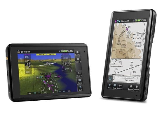
Best For:
The Garmin Aera 660 combines many of the capabilities of panel-mounted avionics into one unit. It is light enough to fit in a flight bag. It quickly and reliably acquires GPS and GLONASS satellite constellations which it combines with advanced navigation tools on interactive aviation maps. The sunlight-readable 5-inch diagonal touchscreen display makes it easy to use in most environments.
Dimensions: 5.5”W x 3.4”H x .8”D (14.1 x 8.7x 2.1 cm)
Weight: 8.64 ounces (245 g) with battery; 7.23 ounces (205 g) without battery
Receiver Type: SBAS/WAAS/GLONASS receiver: hi-sensitivity, WAAS position accuracy
iPad or Tablet Compatibility: No
Removable Antenna: Yes,
- GA 25MCX Remote GPS Antenna
- Low-profile Remote Antenna
EFB Compatibility: No
Bluetooth Connectivity: Yes
WiFi: Yes
Battery: Removable, rechargeable lithium-ion, Up to four hours during most daytime conditions, (80 percent backlight) and wireless connectivity in the cockpit, e.g. GTX 345; up to six hours during typical nighttime conditions, (5 percent backlight) and without wireless connectivity.
Special Features:
- 3D Vision
- Connext
- SafeTaxi
- Fuel prices
- Smart Airspace
- VIRB XE control
- Garmin WireAware
- Wireless database updating
- Preloaded Garmin FliteCharts
- TargetTrend (When paired with compatible devices)
- TerminalTraffic (When paired with compatible devices)
- Animated NEXRAD (When paired with compatible devices)
Benefits:
- Preloaded with detailed flight mapping
- Terrain and obstacles alerting
- AOPA airport directory
- Optional AC-U-KWIK global airport directory
Disadvantages:
- No Jeppesen database
- No separate serial and USB interfaces
- No carrying case included
- Not waterproof
Pricing: $799.00
XGPS190 GPS + ADS-B Dual Band Receiver with AHRS

Best For:
The XGPS190 is a WAAS-capable GPS with a dual-band ADS-B receiver for weather and traffic information. It connects to up to two devices via Bluetooth and is compatible with iPad, Android, and Windows tablets. It has an AHRS artificial horizon for EFB apps with synthetic vision and an internal battery to allow five hours of continuous operation. You can also use it in your car, on a boat, or hiking.
Dimensions: XGPS190 (without the antenna): 4.3″ x 2.7″ x 1.0″
Weight: (with the antenna): 5.3 oz
Receiver Type: ADS-B receiver
Ipad or Tablet Compatibility: Yes,
Removable Antenna: Yes
EFB Compatibility: Yes
Bluetooth Connectivity: Yes, two simultaneously
WiFi: Yes
Battery: Built-in rechargeable battery, five hours of continuous use in ADS-B mode
Special Features:
- Dual-band (978 UAT and 1090 ES) ADS-B receiver
- ADS-B Weather (FIS-B) reception
- ADS-B Traffic (ADS-R/TIS-B) reception
- Attitude and Heading Reference System (AHRS)
- iOS, Android, and Windows EFB software compatible and select GRT EFIS devices
- Adjustable brightness LEDs for day and night flying
- Nonslip pad included to secure XGPS190 on the glare shield or window
Benefits:
- Broad EFB Apps support
- WAAS GPS receiver compatible with any app that requires location information, including apps for car navigation, boating, hiking, etc.
Disadvantages:
- Limited battery
- External antenna
- Customer reports of faulty AHRS
Pricing: $699.99
ILEVIL Sport Portable AHRS GPS
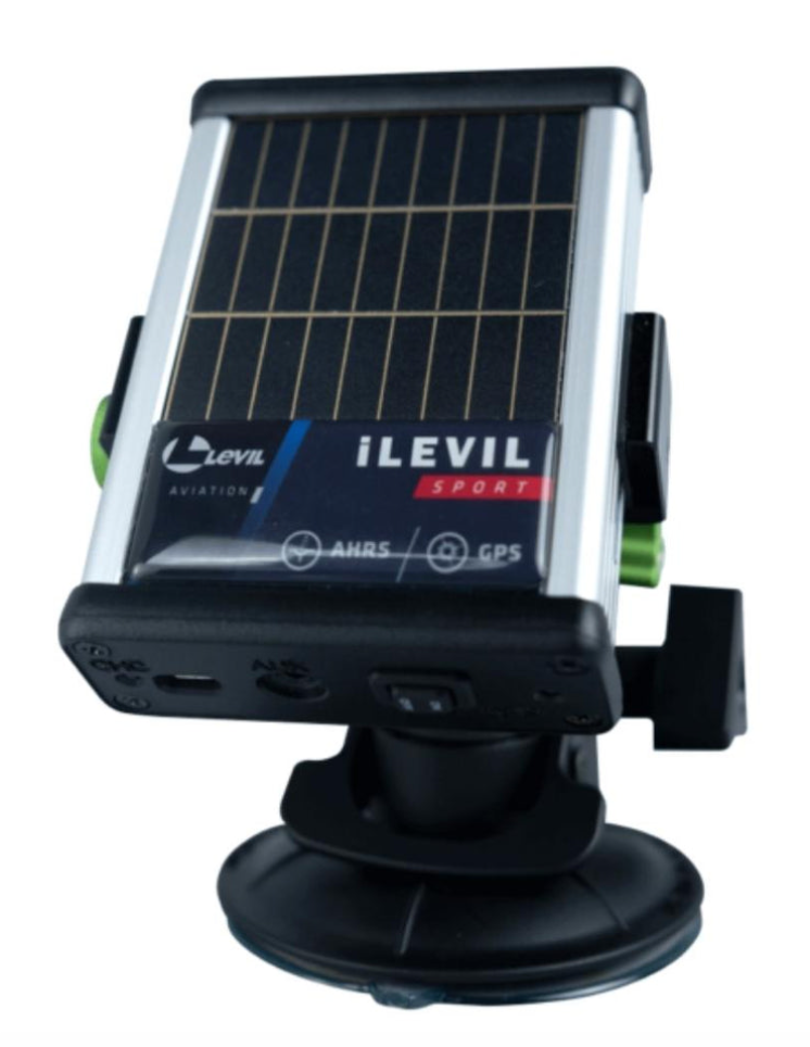
Best For:
The iLevil Sport combines AHRS, GPS technology, and data recording for every pilot. The portable unit is compatible with both iOS and Android and works with various apps. The iLevil Sport can be connected to six devices simultaneously, providing redundancy and almost limitless panel display options. It can record your data and save all of your flight information.
Dimensions: 3.2 x 4.2 x 1.1 in
Weight: 0.3125 lbs
Receiver Type: No
iPad or Tablet Compatibility: Yes
Removable Antenna: No
EFB Compatibility: Yes
Bluetooth Connectivity: No
WiFi: Yes
Battery: Internal battery, 8 hours fully charged + 4 hours of battery life from solar panels
Special Features:
- WAAS GPS inside
- Roll, Pitch, Magnetic Heading, Rate of Turn, Inclination, and G-meter data output
- Wi-Fi Access Point (enables +10 devices connected to the same iLevil)
- Compatible iOS and Android apps
Benefits:
- Integrated solar panels recharge the batteries
- 3-axis gyros, accelerometers and magnetometers
- Micro-USB communication for remote firmware updates, data transfer and charging
- Automatic on/off operation through 3.5 mm audio jack using regulated 5V
- In/out serial communication (allows data transfer)
Disadvantages:
- No ADS-B
- No pitot-static source
- No angle of attack data
- Not NORSEE approved
Pricing: $795.00
Garmin Aera 796
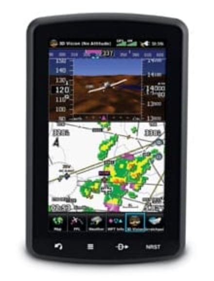
Best For:
The Garmin Aera 796 can replace either a Class I or Class II electronic flight bag and comes with charts preloaded that show your aircraft’s position overlaid directly on the relevant chart. Optional European and Canadian VFR and IFR charts are also available. By adding optional City Navigator maps, helicopter and fixed-wing pilots add street addresses as waypoints or direct-to destinations.
Dimensions: 5.1″W x 8.0″H x 1.5″D (13.0 x 20.3 x 3.8 cm)
Weight: 26.4 ounces (748 g) with battery pack; 18.3 ounces (519 g) without battery pack; 12.7 ounces (361 g) RAM mount
Receiver Type: ADS-B receiver–compatible with GDl 39 receiver
Ipad or Tablet Compatibility: No
Removable Antenna: Yes, GXM 42 antenna, GDL 39 antenna
EFB Compatibility: Yes, Class I/II
Bluetooth Connectivity: Yes, two simultaneously
WiFi: No
Battery: Rechargeable, replaceable lithium-ion, up to 3 hours with full backlight and GXM 40 connected (8 hours with 50% backlighting and XM connected)
Special Features:
Aviation portable features
- Moving map
- Patented panel page
- HSI (GPS-based)
- IFR map mode
- Audible terrain alerts
- Terrain resolution
- Standard smart airspace feature
- Automatic logbook
- Separate serial USB interfaces
- 3D map view
Benefits:
- Maps and memory
- Ability to add maps
- Basemap included
- External memory storage (microSD cards option)
- Databases
- Navigation database (includes Jeppesen data)
- Preloaded terrain database
- Preloaded obstacle database (U.S. and Europe only)
- Preloaded low & high altitude enroute airways
- Preloaded private airports (U.S. only)
Disadvantages:
- Not waterproof
Pricing: $1,599.00
IFLY 740B
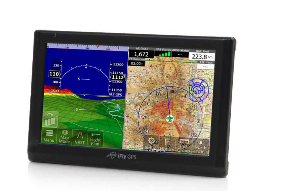
Best For:
The 7-inch touch screen aviation GPS includes a suction mount with multiple articulation points and a touch screen interface that is easy to use. The iFly 740b is loaded with digital copies of FAA sectionals, IFR low enroute charts, airport diagrams, approach plates, etc. It comes equipped with synthetic vision, has built-in power, and is easy to read.
Dimensions: 7.25 x 4.5 x 0.82 inches
Weight: 14.4 ounces
Receiver Type: WAAS-GPS receiver
Ipad or Tablet Compatibility: No
Removable Antenna: Yes
EFB Compatibility: No
Bluetooth Connectivity: No
WiFi: Yes
Battery: 1650 mAh internal circuit protected Li-Po battery
Special Features:
- Preloaded with FAA Sectional Charts, low altitude enroute charts, Approach/Departure Plates, Airport Diagrams
- Soft carrying case
- AC power adapter
- DC power adapter (cigarette lighter style)
- Remote Control
- Multi-point articulating suction mount
- FREE VFR/IFR data subscription for two months
Benefits:
- Small emergency use internal battery but requires external power for regular use
Disadvantages:
- Poor screen resolution
- Not enough battery backup
- No AOPA directory
- No Jeppesen database
- No XM weather capability
- Not waterproof
- No bluetooth interface
Pricing: $599.99
What Is an Aviation GPS Unit?
Aviation GPS systems are designed to meet strict requirements as to shock, vibration, electrical surge, electromagnetic interference, sunlight readability, night visibility, signal acquisition, not required of ground GPS units. Marine GPS systems have similar unique requirements.
How Does an Aviation GPS Work?
Regardless of the type, a GPS receiver needs signals from a minimum of three satellites to provide position information (trilateration), which provides three-dimensional location. A fourth satellite gives you your location exactly (neglecting multipath, ionosphere and troposphere induced errors) that includes elevation. Mobile aviation GPS units are less accurate than hardware installed on the airplane and aren’t suitable for approach procedures.
What To Look For in an Aviation Navigation System
How should you pick the right aviation GPS? Here are some points to consider:
Compatibility
It’s important to ensure that the GPS unit you plan to use is compatible with the rest of your navigation systems, electronic flight bag, mobile devices with different operating systems, or airplane before you make the purchase.
H3: Receiver Type
The receivers used for GPS navigation under VFR vary from a complete IFR installation to support a VFR flight to a VFR-only installation (in either a VFR or IFR capable aircraft) to a hand-held receiver. The limitations of Figures 16-40. Satellite constellation. The pilot must understand each type of receiver installation to avoid misusing navigation information. In all cases, VFR pilots should never rely solely on one navigation system. Pilots must augment GPS navigation with other electronic navigation, pilotage, and dead reckoning. Only through the integration of these techniques can the VFR pilot ensure accuracy in navigation. Some critical concerns in VFR use of GPS include RAIM capability, database currency, and antenna location.
Accuracy
While a handheld GPS receiver can provide excellent navigation capability to VFR pilots, they should be prepared for intermittent loss of navigation signal, possibly with no RAIM warning to the pilot. If mounting the receiver in the aircraft, be sure to comply with 14 CFR Part 43.
Features
While most GPS units will function the same, they may all have unique features, like satellite communication or weather and traffic receivers. Think about what you need in a unit based on your airplane capability, trip profile, and budget.
Plugin or Wireless
Frequently, pilots use their GPS devices with other pieces of technology, such as a mobile phone or tablet. Check to see that the GPS unit you want to use is compatible with the version of iOS or Android device devices you have or your aircraft’s electrical system. Also, verify if your GPS unit has BlueTooth or wireless capabilities that allow you to transfer data or sync with other devices.
Safety Features
Don’t rely on GPS to solve all VFR navigational problems. Unless your GPS is approved for IFR navigation, the unit can assure no standard of accuracy or integrity. Only the pilot can navigate the aircraft, and GPS is just one of the pilot’s tools to do the job.
Ease of Use
Most receivers are not intuitive. The pilot must take the time to learn the various keystrokes, knob functions, and displays used in the receiver’s operation to minimize their head-down time and become familiar with your receiver. Some manufacturers provide computer-based tutorials or simulations of their receivers. Take the time to learn about the particular unit before using it in flight.
Battery Life
Some GPS units have internal batteries, and others need to be powered by the aircraft. Before you make your purchase, pay attention to the power connection. If the unit is independently powered, aim to use one with enough continuous power to match your trip profile.
Which Aviation GPS Is Best for You?
Aviation GPS makes flying easier for pilots. Pilots who plan to purchase portable units have many options based on their needs and budget. Investing in a suitable GPS unit will relieve your workload as a pilot and allow you to enjoy your time in the sky.
FAQ
Is There a GPS for Airplanes?
Airplane GPS helps pilots navigate the globe safely with satellite navigation services and augmented ground control to deliver accuracy. Space-based position and navigation enable three-dimensional position determination for all phases of flight from departure, en route, and arrival, to airport surface navigation.
What Kind of GPS Do Pilots Use?
The GPS pilots use for navigation varies from a complete IFR installation to a VFR-only installation (in either a VFR or IFR capable aircraft) to a handheld receiver. Pilots must understand the limitations of each type of receiver to avoid misusing navigation information.
Will a Garmin GPS Work in an Airplane?
Garmin offers various aviation GPS solutions, including portable GPS, satellite communicators, GPS aviator watches, and more.