fbpx

Flying the Garmin GNS 530

Reflections on an avionics revolution.

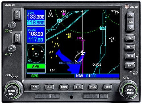
There is no question that avionics systems like the Garmin GNS 530 have captured the fancy of many pilots. I have flown some of the other systems and found them quite capable, but the 530 is what resides in my avionics stack, so it is the most familiar. Other systems can be used in the same ways and for the same things as a 530-the difference is mainly in presentation and organization.

One of my first impressions when I started using the 530 was that it is almost the only piece of equipment in the avionics stack that I use on a regular basis. It handles all the communications and all the navigation, with my other two (three if you count handhelds and four if you count older navcom sets) navigators serving in a standby role or displaying information that I am not showing on the 530. The 530 is also a lot like a personal computer in that it will do many things in a lot of different ways and pilots will use it in different ways. Call it a personal navigator, plus, if you will.

I had a thought about this while flying along. The last time I had an avionics system where one unit served as primary was in my Piper Pacer, in the 1950s, when a Narco Omnigator was numero uno. The Omnigator had a comm transceiver, did VOR and localizer functions (nobody had a glideslope at the time) and had a marker beacon receiver. There were other radios in the panel, but the old Omnigator did most of the work.

Narco advertised that the Omnigator would fit into a standard glove compartment, so it was about the same size as a GNS 530, except the Omnigator required an enormous power supply stuffed full of vacuum tubes and transformers. That big box usually got stuck in the baggage compartment. The Narco had a whopping eight-channel transmitter, and it was said to be the most accurate VOR receiver on the market. The Omnigator weighed 18 pounds compared with 8.4 for a GNS 530. It was accurate enough for IFR flying, and I used it for just that.

At that time pilots were having as much trouble learning to use “omni” as some say they are having with GPS today. Fifty years ago, my father, Leighton Collins, wrote in his Air Facts magazine about the Omnigator. His piece started: “It is easy to imagine some fellow getting a new Narco omni set installed in his airplane, getting out and getting hopelessly confused, and coming back and saying it is no good.” Then, in 16,800 words he explained it. That it took that much space to explain something as dirt simple as an Omnigator says it all about pilots and new equipment. His words about the pilot saying it is no good because the pilot was confused have strong parallels to GPS today, as some whine that it is too complicated.

The new avionics are not complicated; it’s just that in a system like the 530 you have a device that does so much more and presents more information than was available from all sources when I was flying with that Omnigator. The 530 also does a lot more than the avionics it replaces in today’s panel. The challenge with a 530 is to get it set up the way you like it and use it in a way that gets you where you are going and that pleases you most.

For starters, I have become a great believer in stored flight plans and have all 20 flight plan slots filled in the 530 to cover my frequently traveled routes. If I am going to a new place, I put the flight plan in on the previous trip if I know of that next flight at the time. Failing that, I usually enter the whole flight plan in after starting the engine but before taxiing. If the clearance isn’t “as filed” then I fix it in the navigator before takeoff.

The Garmin 530, as well as the smaller 430, has four basic operating modes to cover navigation, waypoint detail, nearest airports and navaids and auxiliary functions. The 530 has four nav pages, two of which are used a lot for primary information. The default nav page, nav one, has a compass arc at the top, with the present ground track displayed like heading is displayed on a directional gyro or horizontal situation indicator. There’s also a digital readout of track and a bearing pointer that does just that-points to the active waypoint. When flying, if I keep the track and the bearing pointer in alignment, presto, the airplane gets where I want it to go.

The nav one page displays the IFR approach selected. The approach is also shown on the nav two page, the true map, but I think that the nav one gives a clearer picture of what is going on with the approach. There is an auto zoom feature on both the nav one and the nav two page that keeps reducing the range of the map as you approach a waypoint, but I like to control the range myself using the rocker switch to adjust the scale of the map. With the auto zoom feature selected, the waypoint moves further away on the map picture as the scale zooms in, and somehow having a point automatically get farther away, on the screen, as I approach it is not my cup of tea.

Other items displayed on the nav one screen, which also includes aviation information and prominent bodies of water, are the pilot’s choice. My choices are bearing and distance to the waypoint, groundspeed and estimated time to the waypoint. Some pilots like to display desired track on this screen. That is the line from the last waypoint to the next or from where you were when you selected a direct to the next waypoint. I don’t show that because my relationship to the desired track is shown on the horizontal situation indicator as well as on the 530’s course deviation indicator, which is only on the nav one screen.

The emphasis on track on this screen is good because track gets you where you want to go, and the word “track” could replace a lot of other words we use in airborne navigation that are at best confusing. For example, we have omni-bearing selectors, but they really select the desired track. A radial is nothing but an electronic signal from a VOR that defines a track across the ground. A course deviation indicator shows us where the desired track is in relation to our position. The bearing to the waypoint, be it digital or with a pointer, just tells us what track we have to fly to get from here to there. If GPS had not had to be laid over an existing airway navigation system and pilots were taught to fly IFR using the terminology of GPS, everything might well be called just plain old track.

The second nav page on the 530 is the map page. Where I use the nav one page when flying approaches or other procedures, I do almost all the rest of my flying with the nav two page displayed. Why? Because it’s fun to have a map. I’m an avid sightseer, and while there’s not much of the country that I haven’t gazed at from a light airplane, I still like to know the name of every town, river or lake. If it doesn’t automatically show on the map, there’s a cursor that can be used to extract the name of points on the map.

The items of information in the stack of data fields on the right side of this screen are also mostly the pilot’s choice. The top one is always the active waypoint, and below that I have bearing, track, groundspeed and distance as my selections. This information can be deleted for a larger map, but I fly with the stack displayed all the time. I found a new use for the map cursor feature on a recent trip that bisected Lakes Erie and Michigan. You can put the cursor on any point and it will tell you the bearing and distance from where you are to that point. Thus you can know the distance to the other side of the lake when starting across and can always know how far you are from either shore as you make the crossing. I had previously figured that out in other ways, but it is a lot easier with the 530.

I learned something on this trip, too. I have always calculated the distance and flown high across Lake Michigan to be within gliding distance of land all the time but haven’t bothered as much with Lake Erie. Guess what? It is just as far across Erie. It might not be as deep, but it’s still over my head.

I usually select the 50-mile range for the map, which, in the track up (as opposed to north up) mode, means that the map is 50 miles from bottom to top. The symbolic airplane is not at the bottom of the map; it is up about 30 percent of the distance regardless of the scale selected. That means, on the 50-mile scale, that you are actually always looking about 35 miles ahead of the airplane. However, when that cursor function is used, the symbolic airplane will fly up the screen to the point you selected. In other words, the airplane, not the map, becomes the moving feature. If desired you can use the cursor to pan around the area without changing the range of the map.

Another neat map feature is the depiction of state lines. I know that this does not have a lot to do with aerial navigation, but I often have passengers ask what state we are flying over. Maybe that tells me they have so little confidence in my navigation that they think the state is the closest I could guess our present position. With the 530 you can always show them. The map range can be extended out to 2,000 nautical miles, so you can show where the airplane is in the big picture as well. Or the map scale can be reduced to 500 feet. And, yes, it will show you right in the middle of the runway when you are right in the middle of the runway. The things displayed on the map at various ranges are up for pilot selection, and it takes a little experimenting to get them the way you want them and not have the map too cluttered at any range selection. Once it’s done, though, it’s unlikely there will ever be any desire to change.

There are a lot of other pages in the 530, and there’s so much information that it’s seldom necessary to look up frequencies or anything else. I didn’t consult charts much before adding the 530 to the stack, and now I almost never use charts. For example, as you are flying along, the third nav page gives all the frequencies for the destination airport you entered in the flight plan, so there’s no need to look up an ATIS, ASOS or any other frequency. This information is available for the departure airport, too, and can be viewed for any other airport along with available approaches and everything else.

The fourth nav page is where you go to see the satellite status and analysis of navigation accuracy, as well as the GPS- calculated altitude of the airplane. The vertical navigation page will calculate the required rate of descent to reach a specified point before the destination at a specified height above the ground. Because I fly IFR most of the time, I start the descents when the controller says, but at a glance I can see what rate of descent to go for when a clearance to descend is issued.

The procedure key is used to select any IFR procedure that you want to fly. It makes these easy to reach, and loading and activating any procedure, whether it be SID, STAR or IFR approach, is logical. The menu key is an important one because it’s where you look to find the available options for whatever page you have displayed. It is where you activate a flight plan or invert and activate a flight plan, for example.

Just because I think of my 530 as primary, that doesn’t mean that I don’t use the other equipment at all. I have an Icarus NavAlert mounted just left of the airspeed indicator and use it to display cross-track error (the difference between desired and actual track) when en route, track when flying an approach and groundspeed if there is any suspicion of wind shear. My Garmin GPS 155XL is used as a backup for the 530. It is always on the current flight plan or approach and ready to become primary.

The trusty old Bendix/King KLN 88 loran navigator still serves as a backup and for some other things. It drives the number two nav indicator, and for some reason the autopilot tracks best when coupled to this. So, for all the GPS finery in the airplane, when the autopilot is nav tracking it is usually doing so using a loran signal. I also keep half the KLN 88 screen on the page to tell what time I took off, how long I have been flying, how long it will take me to get there and what time I will get there. This has to be used with some care. If there’s precip static and the 88 drops off line, the time it is off line is not included in the displayed time that you have been flying, which might foul up a fuel reserve if you were not paying attention. The number two navcom just rests and waits to be called upon to do something. That other thing over there is an ADF that I haven’t used in years. Does it even work?

The final 530 backup is a Garmin GPS III Pilot handheld. I have sung the praises of this relatively inexpensive device many times, and whenever flying in clouds I have it on, running, with the current flight plan in it, ready to be the ultimate standby if everything else flickers and goes away.

Login

New to Flying?

Register

Already have an account?