Approach Considerations

Gemini Sparkle

Key Takeaways:

  • Garmin GPS navigators can use either Garmin or Jeppesen databases, with the Garmin database often including localizer-only approaches and critical stepdown fixes that Jeppesen's may omit, impacting minimums.
  • Pilots should load ground-based approaches for situational awareness but also practice flying ILS approaches without navigator guidance in case of GPS outage.
  • It is crucial to practice non-precision approaches without vertical guidance, as they are required for proficiency checks and prevent over-reliance on vertical guidance.
See a mistake? Contact us.

Garmin GPS navigators can use either of two databases for en-route and terminal navigation. Both are available through Garmin; one is a Garmin product and Jeppesen provides the other. We naturally assume that the two databases are similar, and in most cases they are—but not always, as I recently learned.

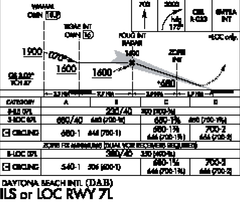
Most of us consider it good practice to load ground-based approaches into our navigators. This allows better situational awareness before intercepting final and provides guidance on the missed. We still fly the final approach course using the ground-based nav.

Most ILS approaches in the U.S. include the localizer-only approach on the same chart. Suppose for proficiency you want to fly the localizer version. You can load that from Garmin’s database, but not from Jeppesen.

Some LOC approaches have a stepdown fix inside the final approach fix. That stepdown often enables lower mins than if you don’t/can’t meet its restrictions. ILS approaches have no stepdown fixes inside the FAF.

Consider the Daytona Beach, Florida, ILS or LOC RWY 7L flown as a LOC approach. ZOPRI is a stepdown fix that, if identified, reduces the S-LOC MDA substantially from 680 feet MSL to 380 feet MSL. Circling MDA is reduced from 680 feet MSL to 540 feet MSL for CAT A and B. Garmin’s database has ZOPRI so it can be easily identified using GPS. Jepp does not have the LOC approach; it only has the ILS and ZOPRI is omitted.

If you load the Jeppesen ILS to fly the localizer only, you can still identify ZOPRI using a cross-radial, or at 1.9 NM GPS to the runway threshold.

With WAAS GPS navigators, depending on the actual installation, it’s common to have vertical guidance from a GPS glidepath on LPV or LNAV/VNAV versions, or at least with an advisory glidepath as in LNAV+V. Of course, there’s an ILS glideslope.

This raises a couple questions. Should ILS and LOC approaches be loaded in GPS navigators? And should we even bother to practice non-precision approaches without vertical guidance?

The first answer is definitely “yes” for the reasons mentioned, but we should sometimes practice flying an ILS without loading the approach in the navigator. This is good practice in the unlikely case of a GPS outage. Remember, that’s why we have all those MON airports.

Should we practice nonprecision approaches without vertical guidance? Yes. A nonprecision approach is required for an instrument checkride and instrument proficiency check. Flying a non-precision approach is more challenging because of the dive-and-drive vertical profile with a hard altitude at the MDA. This is somewhat mitigated with the constant angle technique, but that brings other challenges.

Bottom line is that we shouldn’t get so used to vertical guidance that we can’t remain stabilized without it.

Ready to Sell Your Aircraft?

List your airplane on AircraftForSale.com and reach qualified buyers.

List Your Aircraft
AircraftForSale Logo | FLYING Logo
Pilot in aircraft
Sign-up for newsletters & special offers!

Get the latest stories & special offers delivered directly to your inbox.

SUBSCRIBE