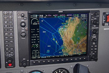

We all remember the tedious work of the manual flight planning required for the Private Pilot certificate, where we spent hours calculating headwind components, ground speeds and, ultimately, the fuel required for the trip. Advanced avionics have made the task of knowing whether you have enough fuel as complicated as entering the fuel remaining and looking at the moving map. A fuel range ring, such as the one on the Garmin G1000, provides a graphical representation of your available range in all directions from your current location.
Provided your avionics has current weather available, the range ring will be anywhere from a perfect circle to an egg shape based on the wind conditions. Naturally, the range line will be farther away from you if you have a tailwind and closer if you have a headwind, creating a semi-oval shape.