Register

Bucket List: Airport in the Sky

Catalina Airport (KAVX) offers pilots a unique challenge and breathtaking views.

Catalina Airport (KAVX), also known as the Airport in the Sky. [Photo: Jeff Berlin]
Gemini Sparkle

Key Takeaways:

  • Catalina Airport (KAVX) is a challenging "bucket list" destination for pilots, known for its mountain-top location, dramatic runway drop-offs, and often requiring special pilot checkouts due to demanding approaches.
  • Navigating to KAVX involves careful planning through the complex Los Angeles basin airspace, and landing requires overcoming visual illusions (like pattern altitude and runway slope) while adhering to specific non-towered airport procedures.
  • Beyond the demanding flight, Catalina offers various attractions, including the famous airport café, hiking, camping, and the amenities of Avalon, though pilots should be aware of landing fees, potential weather delays, and the recently improved but still uneven runway surface.
See a mistake? Contact us.

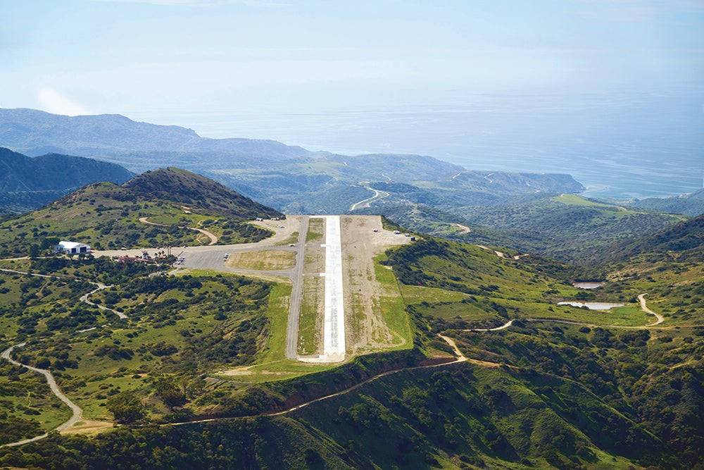
Located 1,602 feet atop a mountain on scenic Catalina Island—offshore of Palos Verdes, California, and easily seen from the coastline of the Los Angeles basin—Catalina Airport is a bucket list destination for many pilots. Many who have been there make it a point to re-turn to enjoy the challenge of the airport and all that the area has to offer. Much like the iconic Sedona Air-port in Arizona, the ground drops off dramatically at each end of the 3,000-foot runway, making the approach challenging enough that most LA-region aircraft rental facilities require a special checkout for pilots who want to take an airplane to the island. If you’re looking for a fun challenge, Catalina is a terrific choice that also offers great attractions and delicious food.

The main town of Avalon on Catalina Island surrounds the harbor and offers shelter for pilots and sailors alike. [Photo: Jeff Berlin]

Getting There

The first challenge of flying to KAVX lies in the approach from the mainland. As displayed on a sectional or terminal area chart, the Los Angeles basin looks much like a poorly assembled quilt filled with multiple layers of Class B, Class C, and Class D airspace, as well as a permanent TFR. While navigating this mess might be intimidating for pilots not familiar with the area, it’s just a matter of studying the chart to determine the best route and altitude to fly to stay out of the way of airspace you absolutely cannot fly through. The rest is easily handled by communicating with SoCal Approach.

Pia Bergqvist

Pia Bergqvist joined FLYING in December 2010. A passionate aviator, Pia started flying in 1999 and quickly obtained her single- and multi-engine commercial, instrument and instructor ratings. After a decade of working in general aviation, Pia has accumulated almost 3,000 hours of flight time in nearly 40 different types of aircraft.

Ready to Sell Your Aircraft?

List your airplane on AircraftForSale.com and reach qualified buyers.

List Your Aircraft
AircraftForSale Logo | FLYING Logo
Pilot in aircraft
Sign-up for newsletters & special offers!

Get the latest stories & special offers delivered directly to your inbox.

SUBSCRIBE