
ForeFlight’s latest update is now available to new and current subscribers and comes with some useful new features.
Enhanced Weight and Balance
The new weight and balance view allows for simpler weight and balance profiles to be created, edited, and planned. It offers fields for entering load information, the weight and CG graph, significant weight values, and detailed weight and balance information.
The new features are designed to help streamline the planning process by allowing the pilot to choose standard weight options, male, female, or child, or to select from saved loads.
Weight and Balance Integrated with Flights
In addition to a newly customizable weight and balance tab, the new ForeFlight Performance software is equipped with the ability to directly integrate weight and balance with flight planning. This update aids in preflight workflow and produces more accurate time and fuel calculations. The new integration will make responding to last-minute payload changes and accessing the load manifest seamless in the “Flights” view, instead of requiring pilots to switch back to the weight and balance tab.
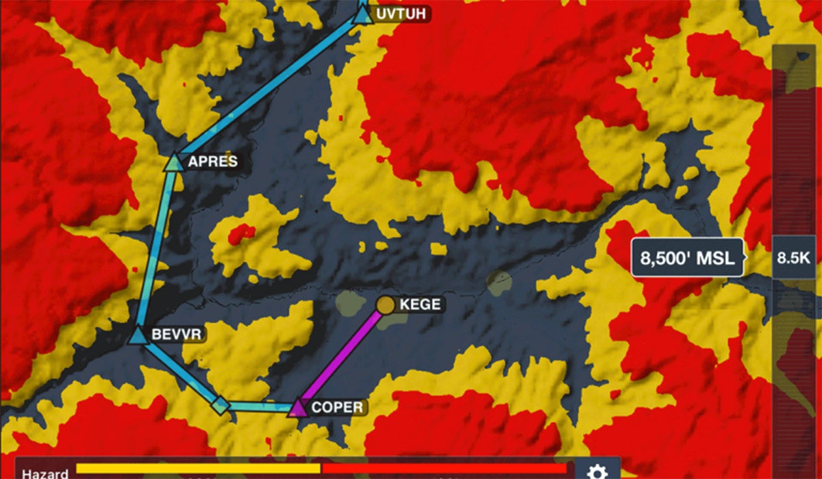
Hazard Advisor Altitude Preview
For Pro Plus subscribers, there’s a new feature that makes planning around terrain much easier. The Hazard Advisor Altitude Preview can aid in finding the safest route around hazardous terrain at different altitudes before or during flight.
ForeFlight Military Flight Bag customers also have additional features, such as defining custom hazard altitudes beyond the four default options. The manually controlled Hazard Advisor can detect terrain between 100 feet and 30,000 feet msl, moving in increments of 100 feet up to 4,000 feet, and then in increments of 500 feet. In the viewing window, default settings will display all hazards and obstacles within 100 feet in red and hazards within 1,000 feet will show in yellow. These standard altitude settings can be changed in the map legend.
Organized Track Systems on Jeppesen Enroute Charts
Performance customers with Jeppesen chart coverages can now view organized track systems on Jeppesen’s IFR enroute map layers, in addition to the aeronautical map. The IFR maps can be viewed east or westbound or be disabled altogether.