













Readback—November 2024

Gemini Sparkle

Key Takeaways:

  • GPS spoofing, while rare, can be detected by a sudden jump in reported time or position, requiring verification against an independent, non-GPS time source.
  • Pilot professionalism is highlighted through the importance of making difficult "No-Go" decisions in pre-flight planning and using clear, constructive radio communication (e.g., N numbers) on CTAF.
  • While not legally mandated for general aviation by FAR §91.503, checklists are essential for safe operations, and complex hybrid approach procedures often accommodate both GPS (4-NM legs) and conventional (one-minute DME/LOC) navigation for holds.
See a mistake? Contact us.

Spoofing Confusion

I enjoyed your “GPS Jamming, Spoofing” article in June 2024. Would you please expand on your comment that “GPS satellite spoofing attacks are often detected by a jump in the time reported from the GPS.”? 

Where would I check to see if there was a “jump in the GPS time”? Does that mean that the time shown on the GPS status page won’t match the current time? We currently have a WAAS-enabled Garmin GNS 530 but are planning to upgrade the entire panel in six months.


—Jeff Ackerman, Greensboro, North Carolina

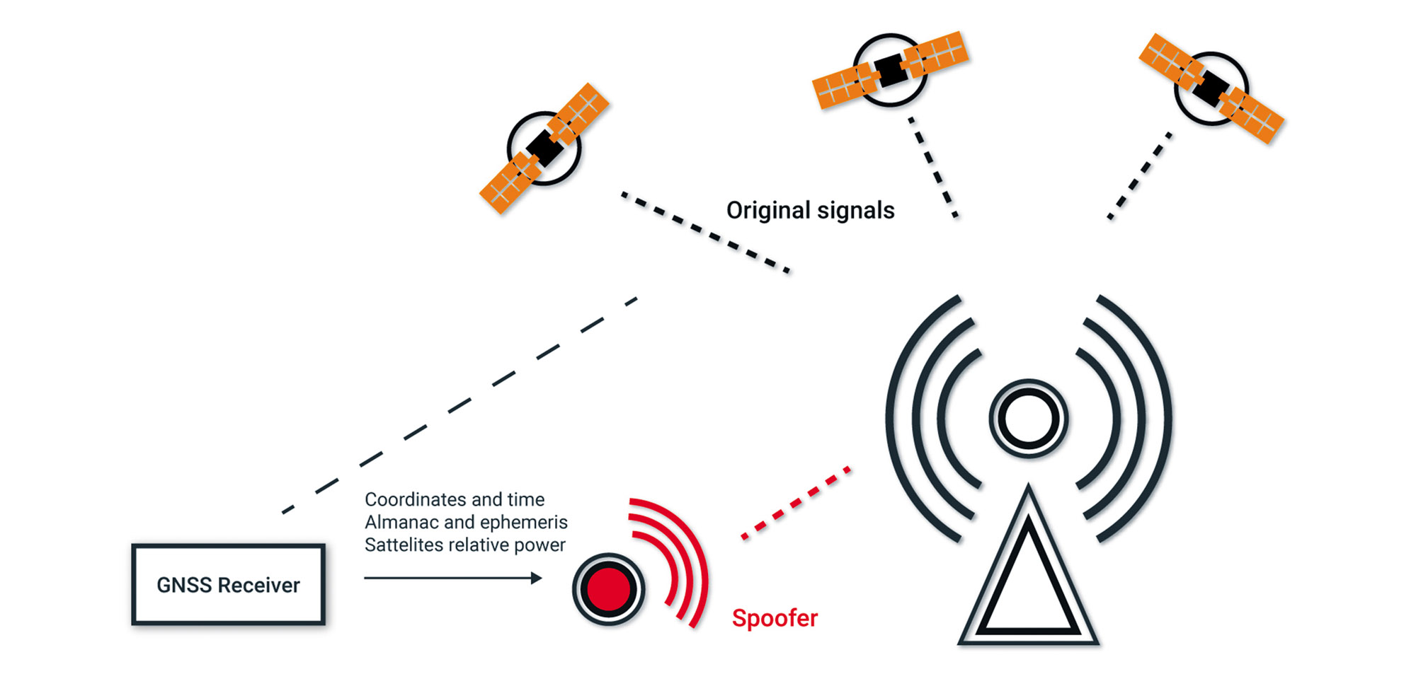
When the spoofer takes over, the false signals will “slide in” to prevent the receiver from unlocking, but it leaves a telltale sign of a jump in both time and position. The time difference is proportional to the distance error that is introduced. System time will only return to the correct time when the spoofing disappears. 

To check if a jump in GPS time occurred, go to the GPS (or Satellite) Status page. Check the time shown against an independent time source, such as an old-fashioned but accurate wristwatch. Don’t check it against the time indicated on your iWatch, iPhone or Android device because it is also directly or indirectly GPS time-based. 

You can also cross-check your position using VOR/DME. Jamming is more prevalent as the attacker only has to overpower the GPS signals. Spoofing is an order of magnitude more complicated and is rarely seen outside conflict zones. —Bob Teter

Likes IFR Clinic (Now IFR Files)

I especially enjoyed Elaine Kauh’s IFR Clinic in September, 2024, “It Doesn’t Always Work.”

Sometimes I feel I am being over-cautious in the extent of my pre-flight planning prior to visiting an unfamiliar airfield.

This can include a period of some days weather watching, on-line spying on other pilots and of course extensive analysis of local facilities and aircraft performance.

All very disappointing when it ends in a “No-Go” decision. 

As was pointed out recently, it is actually easier to make the decision  to go—so saying “No” is difficult and can lead to (non-fatal) self and passenger recriminations.

Not having bothered to study the title of the article, but putting myself in the planning seat as I read, I was becoming more and more unenthusiastic about proceeding, so it was nice to finally discover that the author had come to the same decision.

There are so many “stupid pilot” stories now available on-line, all very fascinating and instructive, but accounts of professional behavior are somewhat scarce. I make it a point to share these with my fellow pilots!

—Chris Kelman, Canberra, Australian Capital Territory

Thank you for your kind words, Chris.

Be Nice and Helpful

(Editor’s note: This was sent in as an OTA, but it makes more sense here in Readback.)

On a dark night over the Everglades, I was flying near the non-towered Pahokee Airport in south-central Florida when I heard on the CTAF: “White and blue Cessna with a black stripe, 10 miles south of Pahokee transitioning north.” 

No other airplane was on the CTAF, and I felt a bit snarky that night. I took a deep breath and made a transmission. “I’m a white and blue Mooney with a splash of silver and black, 15 miles east of Pahokee. Perhaps the Cessna will be able to see my colors when we are up close and personal.” Hoping that he would get the point.

Reflecting on the exchange, I realized my transmission may not have been constructive. I suggested to the Cessna pilot that it’s crucial to communicate the N number, especially given the proliferation of ADS-B Traffic capabilities. His response to my suggestion sounded friendly. 

<Name withheld by request>

Checklist Mandatory?

I was surprised when I read “Custom Checklists” by Fred Simonds in the July issue and saw this statement, “The regs say we must have checklists accessible at our pilot station (§91.503).” 

While I’m sure this applies to some readers, §91.503 is in Subpart F that applies to “Large and Turbine-Powered Multiengine Airplanes and Fractional Ownership Program Aircraft” and not to most of us GA flyers. I could be misinterpreting this and if I am, I apologize. If I’m right, I hope your email inbox is overflowing with others who also caught this.

—Jim Thumm, <Location withheld>

Jim, you are absolutely correct. I found the regulation but should have looked higher in the subpart, where I would have discovered it was Subpart F, which does not apply to us in piston GA.

Still, regulation or not, it’s common sense that the checklist should always be close at hand. —Fred Simonds

Holding Ambiguity

I recently looked at the Olive Branch, Mississippi (KOLV), ILS Runway 18 approach. At first glance, it seems normal enough, but on a closer examination, I realized it’s a hybrid approach, potentially utilizing both GPS and ground-based nav.

But, what really puzzled me is the hold on the localizer at EFPUB. Is it a four-NM GPS hold, or is it a conventional one-minute hold at a DME fix on the localizer? Both are shown. Can you sort this out for me?

—Monty Watson, Salinas, California

Well, Monty, is that hold a GPS hold or a DME/LOC hold? The answer is, “Yes.” 

Note that the approach can be flown with conventional navigation—no GPS required. What makes it a hybrid is mainly the depiction of a Terminal Arrival Area (TAA, not be to confused here with Technically Advanced Aircraft). For aircraft not equipped to fly the TAA, there’s also a conventional Minimum Safe Altitude circle published.

So, as it turns out, that hold can be flown with 4-NM legs using GPS, or you can also fly the entire procedure, including that hold, using terrestrial nav referencing the MSA. as a result, the hold is published to accommodate either type of navigation.

Bottom line: Take your pick—GPS and 4-NM legs or DME/LOC with one-minute legs. Of course, if you choose the latter, you can still use GPS to substitute for DME. 

Yes, this is quite a confusing depiction.


We read ’em all and try to answer most e-mail, but it can take a month or more. Please be sure to include your full name and location for publication. Contact us at Frank@IFR-Magazine.com.

Ready to Sell Your Aircraft?

List your airplane on AircraftForSale.com and reach qualified buyers.

List Your Aircraft
AircraftForSale Logo | FLYING Logo
Pilot in aircraft
Sign-up for newsletters & special offers!

Get the latest stories & special offers delivered directly to your inbox.

SUBSCRIBE